Locory Every place has a story.
Login Sign Up
My Account
Open Map Create a Locory My Locories Featured Regions Leaderboard About What is a Locory? Collaboration Blog Feedback
Login Sign Up
My Account
  1. Home
  2. Seattle Underground (Pioneer Square subterranean streets)
Locory page

Seattle Underground (Pioneer Square subterranean streets)

By Seeker 6mo ago
See on map
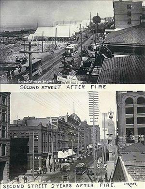
Seattle Underground (Pioneer Square subterranean streets) photo 1
Seattle Underground (Pioneer Square subterranean streets) photo 2
After the Great Seattle Fire of 1889 the city raised street levels in Pioneer Square, leaving original sidewalks and storefronts beneath the current street system; these buried spaces are collectively known as the Seattle Underground. Portions of the Underground include intact late-19th-century building facades, sidewalks, utility conduits, and entrances that were part of the city's original infrastructure. Guided tours operate from a Pioneer Square ticket office at the address below and provide public access to sections of these historic subterranean passages.
Tags
Historical Art / Graffiti Buried Underground Underground Spots Old Infrastructure
Location
47.596251, -122.334206
Views
0

Comments

0
Be the first to comment!
Share
S
Locory name
Location details
Link to share
Link copied to clipboard
Report Locory
Locory

Discover, share, and explore community-driven points of interest with Locory.

Follow Us

About Contact Documentation Collaboration Upcoming Privacy Policy Terms of Service Accessibility Mailing List Wiki