Locory page
Weedin Place Fallout Shelter
By Seeker

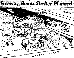
The Weedin Place Fallout Shelter, located in Seattle, Washington, is a unique historical site built between 1962 and 1963 under Interstate 5. Designed to accommodate around 100 individuals, this 3,000 square foot structure features thick concrete walls and was intended as a prototype for similar shelters across the U.S. It includes essential amenities like diesel generators and an air circulation system. Although it was never stocked with supplies and has not been used for its original purpose, it stands as a significant example of Cold War-era preparedness. The shelter is categorized as a bridge by the Washington State Department of Transportation and is eligible for the National Register of Historic Places, making it an intriguing destination for tourists and researchers interested in history and architecture.
Tags
Location
Views
1
Be the first to comment!